

New modelling by the British Geological Survey (BGS) has predicted millions more UK homes could become vulnerable to subsidence as summers grow warmer and drier.
The BGS has published a new GeoClimate Shrink–Swell dataset that combines 1:50,000-scale geological mapping with high-resolution climate projections from the UK Centre for Ecology & Hydrology (UKCEH).
The dataset models how shrink–swell behaviour in clay-rich soils, which is a common cause of subsidence, is likely to change under low, medium and high greenhouse‑gas emissions pathways up to 2070.
Shrink–swell movement occurs when clay minerals absorb water and expand during wet conditions, then contract as they dry.
According to the BGS, the process is responsible for some of the most damaging ground movement in the UK and is already imposing substantial costs.
The Association of British Insurers (ABI) reported subsidence-related insurance claims reached £153M in the first six months of last year.
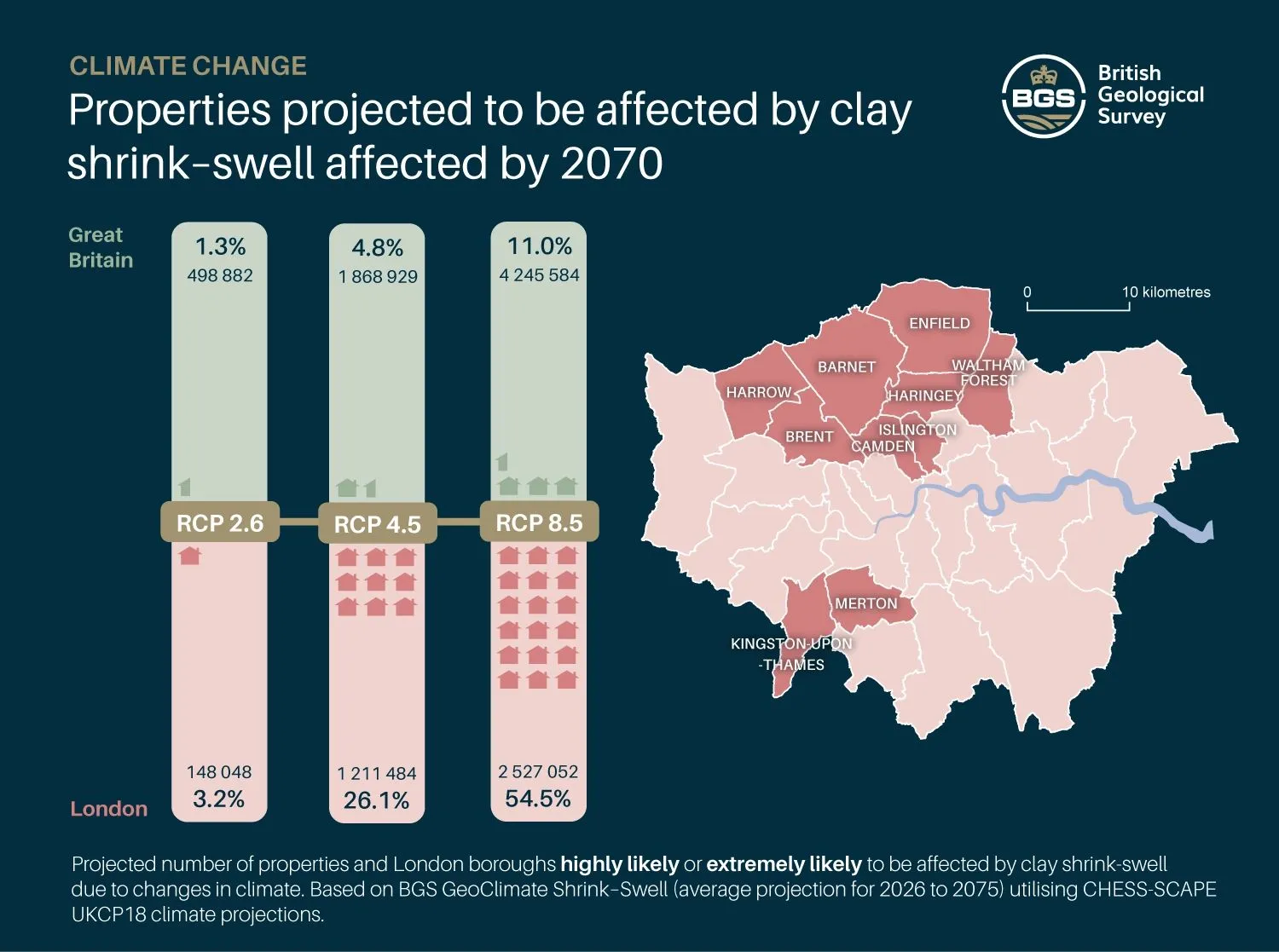
Under the BGS medium emissions scenario, the proportion of properties classed as “highly likely” or “extremely likely” to be susceptible to clay shrink–swell rises to 5% of UK properties by 2070, more than 1.8M homes.
This increases to roughly 11%, or just over 4.2M properties, in the higher emissions trajectory.
Even under the low emissions scenario aligned with the Paris Agreement, the dataset projects around 500,000 affected properties by 2070.
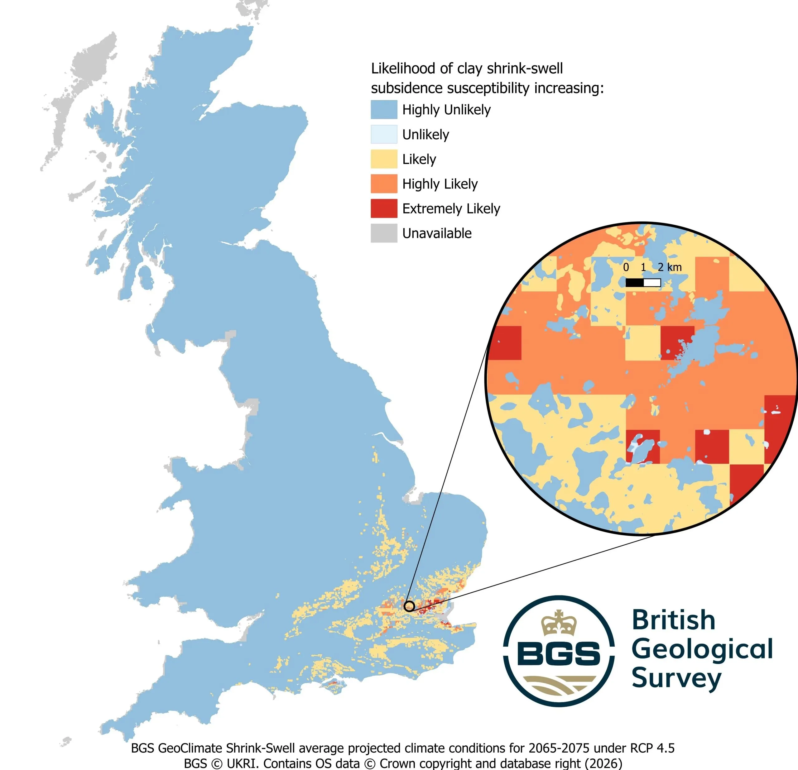
The maps indicate particular concentration of risk in urban and densely populated areas, most notably London and parts of south‑east England.
Under the medium emissions path, the proportion of London properties likely to be affected exceeds 26% by 2070 and under the high emissions path the figure could reach 54%, with more than 2.5M properties in the capital classed as highly likely or extremely likely to experience subsidence impacts.
Vulnerable areas highlighted include London boroughs such as Camden, Islington, Barnet and Merton, as well as parts of Kent.
BGS says the dataset is intended to inform local authorities, developers, planners, conveyancers, mortgage lenders and insurers so they can assess and mitigate subsidence risk at regional and property level. Potential responses range from planning and design changes to targeted ground stabilisation and alterations to insurance and lending decisions.
Subsidence can also affect major infrastructure and utilities, leading to maintenance and renewal engineering works.
The new maps come after an unusually dry and warm 2025 where the UK experienced its warmest spring on record and the driest in more than 50 years.
Climate scientists say hotter, drier summers are expected to become more frequent as global temperatures rise.
BGS applied quaternary scientist Anna Harrison said: “By combining geotechnical information about volume change potential with data about projected rainfall and temperature scenarios for the coming century, we have been able to identify the areas of Great Britain most likely to become susceptible to shrink–swell subsidence in the future.
“Dry weather and high temperatures are a major factor in the emergence of shrink–swell subsidence. Looking ahead, these increases in hotter, drier summers and warmer, wetter winters are projected to continue.”
She added: “Whilst we should be careful to note that these are projections, there are a number of ways planners, property owners and developers can help limit the potential effects of future subsidence-related issues, including taking specialist advice before starting major building work, avoiding planting trees with larger root systems close to properties, and ensuring the foundation designs of new constructions or extensions take into account the impact of climate change on shrinkable clays.”
Like what you’ve read? To receive New Civil Engineer’s daily and weekly newsletters click here.